Represents a system which allows the rapid estimation of ground motion generated by earthquakes, taking into account also real data from seismic stations of the Romanian Seismic Network.
Characteristics
- Allows the rapid estimation of ground motion due to an earthquake, highlighting areas exposed to a specific hazard level.
- Results are generated automatically, in 3-4 minutes after the occurrence of an earthquake with magnitude ≥ 3 in Romania and nearby. As new data becomes available, maps are updated.
- The system relies on the last version (v4) developed by the United States Geological Survey (USGS), USA, adapted by INFP to intermediate-depth and crustal earthquake characteristics in Romania and local site conditions.
- It offers input for Seisdaro (The system for the rapid estimation of seismic damage in Romania).

Input and output data for ShakeMap
Examples of applications
ShakeMaps, generated immediately after a felt earthquake or for representative scenarios, are very important for:
- a prompt emergency response and better targeted emergency intervention;
- intervention planning, proper training and allocation of resources in case of an earthquake;
- estimation of seismic damage and socio-economic losses, with applications also in the insurance and reinsurance sector;
- seismological and earthquake engineering research;
- general public education and outreach.
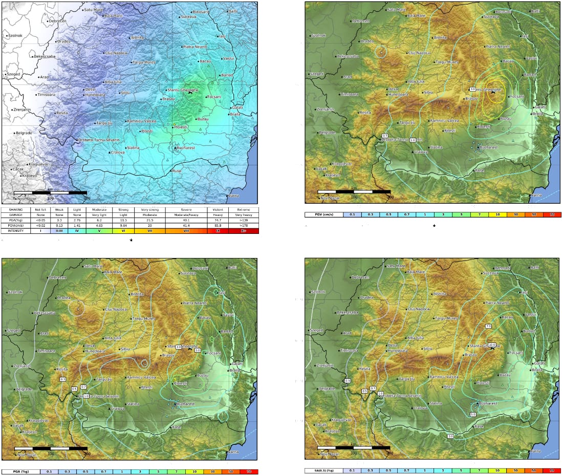
ShakeMap output (replay with ShakeMap v4) for the 27 October 2004 earthquake (Mw 6.0, 96 km depth)
A part of ShakeMap results can be viewed here
ShakeMap contribution to scientific publications
- B. Grecu. A. Danet, L. Manea, E. F. Manea, A. P. Constantin, C. Neagoe, C. Ionescu (2019) Next-Generation of ShakeMap for Romania and Neighboring Countries, 10th Congress of Balkan Geophysical Society, 18-22 September 2019, Albena, Bulgaria
- Moldovan, I. A., Manea, L., Constantin, A. P., Grecu, B., & Toma-Danila, D. (2018). Rapid seismic intensity assessment in Romania using internet macroseismology. International Multidisciplinary Scientific GeoConference: SGEM: Surveying Geology & Mining Ecology Management, 18, 931-938.
- Grecu, B., Toma-Danila, D., Tataru, D., Ionescu, C., & Danet, A. (2017). Romanian seismic network: from earthquake monitoring to its role in decision making. International Multidisciplinary Scientific GeoConference: SGEM: Surveying Geology & Mining Ecology Management, 17(1.4), 357-364.
- Toma-Danila, D., & Cioflan, C. O. (2017). Enhancing earthquake shakemaps for Romania, by using azimuthal analysis and crowd-sourced intensity data. International Multidisciplinary Scientific GeoConference: SGEM: Surveying Geology & Mining Ecology Management, 17(1.4), 119-126.
- Constantin, A. P., & Pantea, A. (2013). Macroseismic field of the October 27, 2004 Vrancea (Romania) moderate subcrustal earthquake. Journal of seismology, 17(4), 1149-1156.
- Ardeleanu, L., Grecu, B., & Raileanu, V. (2012). Peak ground acceleration, velocity and displacement from moderate magnitude under crustal earthquakes of Vrancea region. Romanian Reports in Physics, 64(2), 555-570.
- Ionescu, C., & Dragoicea, M. (2010). Macroseis: a tool for real-time collecting and querying macroseismic data in Romania. Romanian Journal of Physics, 55(7-8), 852-861.
- Sokolov, V., Bonjer, K.-P., Wenzel, F., Grecu, B., and Radulian, M., (2008). Ground-motion prediction equations for the intermediate-depth Vrancea (Romania) earthquakes, Bulletin of Earthquake Engineering 6, 367–388.
- Bonjer, K. P., Ionescu, C., Sokolov, V., Radulian, M., Grecu, B., Popa, M., & Popescu, E. (2008). Ground motion patterns of intermediate-depth Vrancea earthquakes: the October 27, 2004 event. In Harmonization of Seismic Hazard in Vrancea Zone (pp. 47-62). Springer, Dordrecht.
- Ionescu, C.; Danet, A.; Sorensen, M. B.; Zaharia, B.; Stromeyer, D.; Grunthal, G. (2007), Implementation of the Near Real Time ShakeMap System in Romania. American Geophysical Union, Fall Meeting 2007, abstract #S51A-0215.
- Sorensen, M. B., Stromeyer, D., Grunthal, G., Danet, A., & Ionescu, C. (2007). Attenuation of Macroseismic Intensity-New Relations for Different Parts of Europe. In AGU Fall Meeting Abstracts.
- Bartlakowski, J., Wenzel, F., Radulian, M., Ritter, J. R., & Wirth, W. (2006). Urban shakemap methodology for Bucharest. Geophysical research letters, 33(14).
- Bonjer, K. P., Rizescu, M., Grecu, B., Sokolov, V., Radulian, M., & Dinu, C. (2002). Ground motion pattern of large and moderate intermediate depth Vrancea earthquakes: first steps towards the generation of regional shakemaps in Romania. In Conference Earthquake Loss Estimation and Risk Reduction, Bucharest (pp. 24-26).
For a detailed offer and collaboration proposals, contact us at: contact[_at_]infp.ro or +40214050670
DOWNLOAD THE PDF BROCHURE